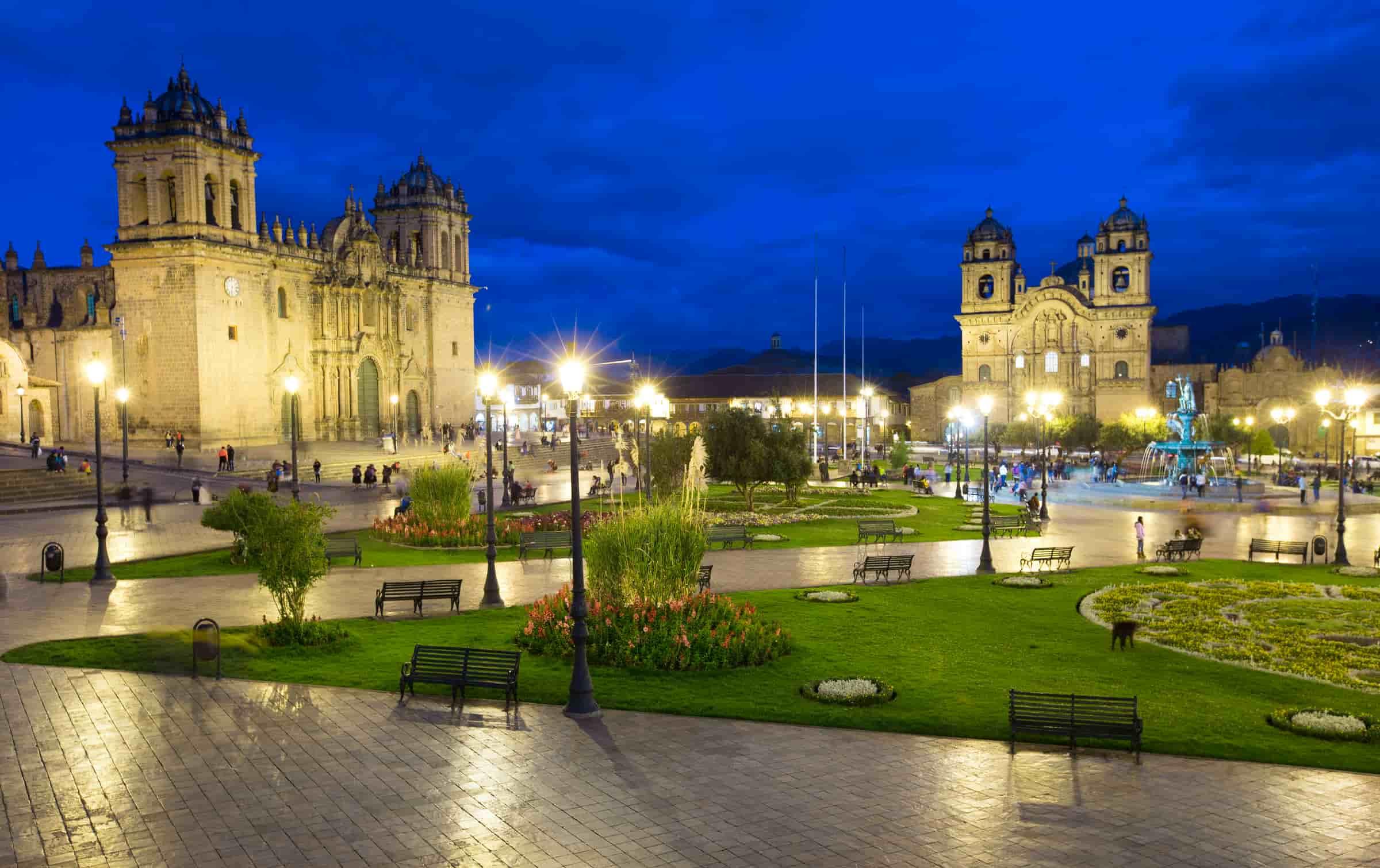
The city of Cusco is located in the western part of the valley of the river Watanay, at a height of 3,350 meters and is considered one of the highest cities of the world. Situated in the Peruvian Andes, Cuzco developed, under the Inca ruler Pachacutec, into a complex urban centre with distinct religious and administrative functions. It was surrounded by clearly delineated areas for agricultural, artisan and industrial production. When the Spaniards conquered it in the 16th century, they preserved the basic structure but built Baroque churches and palaces over the ruins of the Inca city.
Location
Andean Area in the south of Peru, 11,151 feet (3,399 m.) above sea level.
Distances
- From Lima 724 miles (1,165 km) (by Nazca)
- From Arequipa 388 miles (625 km)
- From Puno: 241 miles (389 km)
Cusco is supported by more than 3000 years of age to be considered as The Oldest Existing City of America. Cusco, and its cultural and geographical diversity, has suffered and enjoyed different events through the years that have turned it into a historical study center and the most important tourist core of the country.
Visit PerúThere is some uncertainty about the correct name of the city. According to some chroniclers, in the first centuries of the existence of this most important city in pre-Columbian South-America, its name was Akamama that according to Guaman Poma de Ayala means “chicha’s mother” (chicha is a fermented corn beer). Possibly it was Aqhamama -in the modern Quechua spelling- or “chicha mother”. Surely that name became useless by the beginning of the Inkan development. When this was the ancient Capital of the Tawantinsuyo, it was named as Qosqo, word that is translated as “navel” or “center”. That is the regular name for any Quechua speaking Andean Man.
After the Spanish invasion in 1533 the name was transformed into Cuzco, word that according to the Spanish language dictionary is contemptuous, meaning “hypocrite”, “humpback” and “small dog”. This was a way to minimize or satirize the name of the city. Later the name was changed into Cusco.
There are many legends about the origin of the Twantinsuyo (the Inca). One of them tells how, Manco Cápac and his sister and wife Mama Ocllo, half gods and children of the Inti father (the god of the sun), emerged from the waters of Lake Titicaca with the mission to found a new Kingdom that would improve the conditions of life in the towns.
MACHU PICCHU: WONDER OF THE MODERN WORLD
Location
The Machupicchu archaeological complex is located in the department of Cusco, in the Urubamba province and district of Machupicchu. It is perched on the eastern slopes of the Vilcanota mountain range, a chain of mountains curtailed by the Apurimac and Urubamba Rivers. At latitude 13º7′ South and longitude 72035′ West of the Greenwich Meridian, Machupicchu is located at a height of 2,350 meters above sea level (main square).
Climate and Environment
It is located in a subtropical zone, or dense wood, the reason why the climate is mild, warm and damp, with an average year-round temperature of 130C during the day. One can perceive two distinct seasons during the year: the rainy season from November to March, which is a time of heavy rains. Visitors are advised to dress accordingly during this season. The dry season from April to October brings on higher temperatures.
Flora and Fauna
Both are abundant and varied. Typical plant life in the historic reserve of Machupicchu includes pisonayes, q’eofias, alisos, puya palm trees, ferns and more than 90 species of orchids.
The fauna in the reserve includes the spectacled bear, cock-of-the-rocks or “tunqui”, tankas, wildcats and an impressive variety of butterflies and insects unique in the region.
The lie of the land, the natural surroundings and the strategic location of Machupicchu lend this monument a fusion of beauty, harmony and balance between the work of the ancient Peruvians and the whims of nature.
History
One cannot pinpoint the first to populate these lands, as it was a time of occupation rather than foundations. Machupicchu was visited by explorers well before Hiram Bingham, although with little success. These included Antonio Raymondi, the Count of Sartiges and Charles Wiener. Other visits included one in July 1909 by the Santander brothers, whose inscription can be found carved into the base of the Temple of the Sun. At the same time, Peruvian explorers Enrique Palma, Augustin Lizárraga and Gavino Sánchez arrived at the citadel by the route of San Miguel.
The railway line runs parallel to the river in winding loops that follow the riverbed. From here one can seethe typical vegetation of the upper jungle, which climbs up to the top of the steep mountain range that forms the Urubamba Canyon. The train passes through the Chilca train station from where one can see the snowcapped peak called “Veronica”. With a height of 5,750 meters above sea level, it is the highest peak in the Urubamba range. The train stops at Kilometer 88, where the Inca Trail begins.
The train then continues on its way, passing through the station of Pampacahua and the town of Aguas Calientes, located at Kilometer 110. When the train line comes up against a wall of imposing granite mountains, it then plunges into two tunnels before arriving at the station of Puente Ruinas. From here, minibuses take the travelers up 8 kilometers of roads up to the Tourist Hotel. The entry control to the Inca citadel is done near the hotel.
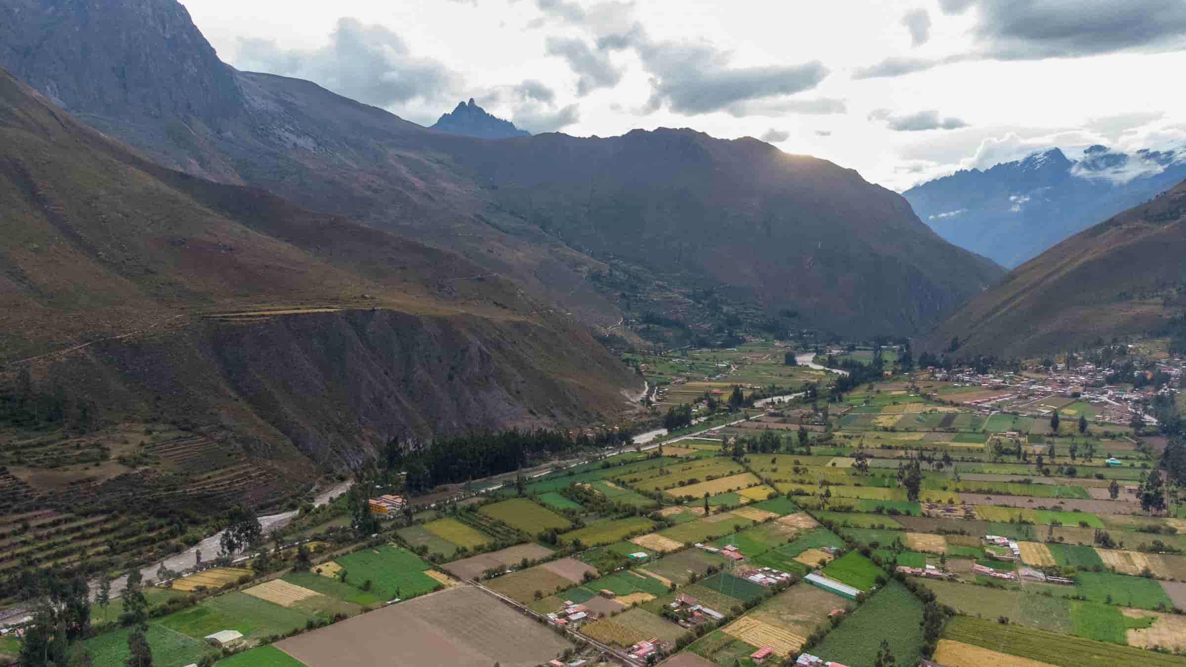
SACRED VALLEY OF THE INKAS
Calca
This area has a beautiful landscape, surrounded by the Pitusiray and Sawasiray snow-capped mountains. The archaeological complex of Huchuy Qosqo is located in this province, as well as the medicinal hot mineral baths of Machacancha (sulfurous hot water) and Minasmoqo (cold bubbling mineral water) It is located 50 km from Cusco.
Chinchero
A former Inca agricultural center, this district of the province of Urubamba i made up of 10 “Ayllus” or indigenous communities. Located at 3,762 mete above sea level, Chinchero is 28 km down a modem highway from the Cusco tourist circuit. It possesses a beautiful Andean landscape and is surrounded by the year-round snow-capped peaks of Chicón, Pumahuanca, Wakay Willca the sacred teardrop (commonly Called wayna willca or Veronica) .
The current town of Chinchero is a blend of Andean and Hispanic architec and is also home to a unique archaeological complex, with the remains o buildings, places of worship, and terraces for crops and for foundations .
It boast a beautiful colonial church with paintings by famous indigenous artist Chiwantito There is also a typical Sunday market, colorful and authentic where indigenous peasants from different communities congregate to trade their goods, not only in money but also trading by barter. It is well-known for its woven handcraft of the region.
Maras
Maras is a district of the Urubamba province, possible to be reached through a paved road from kilometer 50 on the road Qosqo – Chinchero – Urubamba. It is located towards the west of Qosqo at an altitude of 3300 mts. (10824 feet). It was declared ” Villa of Saint Francis of Assisi of Maras” (Villa: city or town that had certain privileges).
Maras village is famous for ”salt works”, These mines were exploited from pre-Hispanic time. The Maras “salt works” to which some people call “salt mines” are constituted by about 3000 small pools with an average area of 5 m² (53.8 ft²), constructed in a slope of the “Qaqawiñay” mountain. People fill up or “irrigate” the pools during the dry season every 3 days, with salty water emanating from a natural spring located on the top of the complex, so that when water evaporates the salt contained in it will slowly solidify.
That process will be carried out approximately during one month until a considerable volume of solid salt is obtained; about 10 cms. (4 inches) high from the floor. That solid salt is beaten thus granulated, then packed in plastic sacks and sent to the region’s markets; today that salt began being treated with iodine, thus, its consumption is not harmful.
Moray
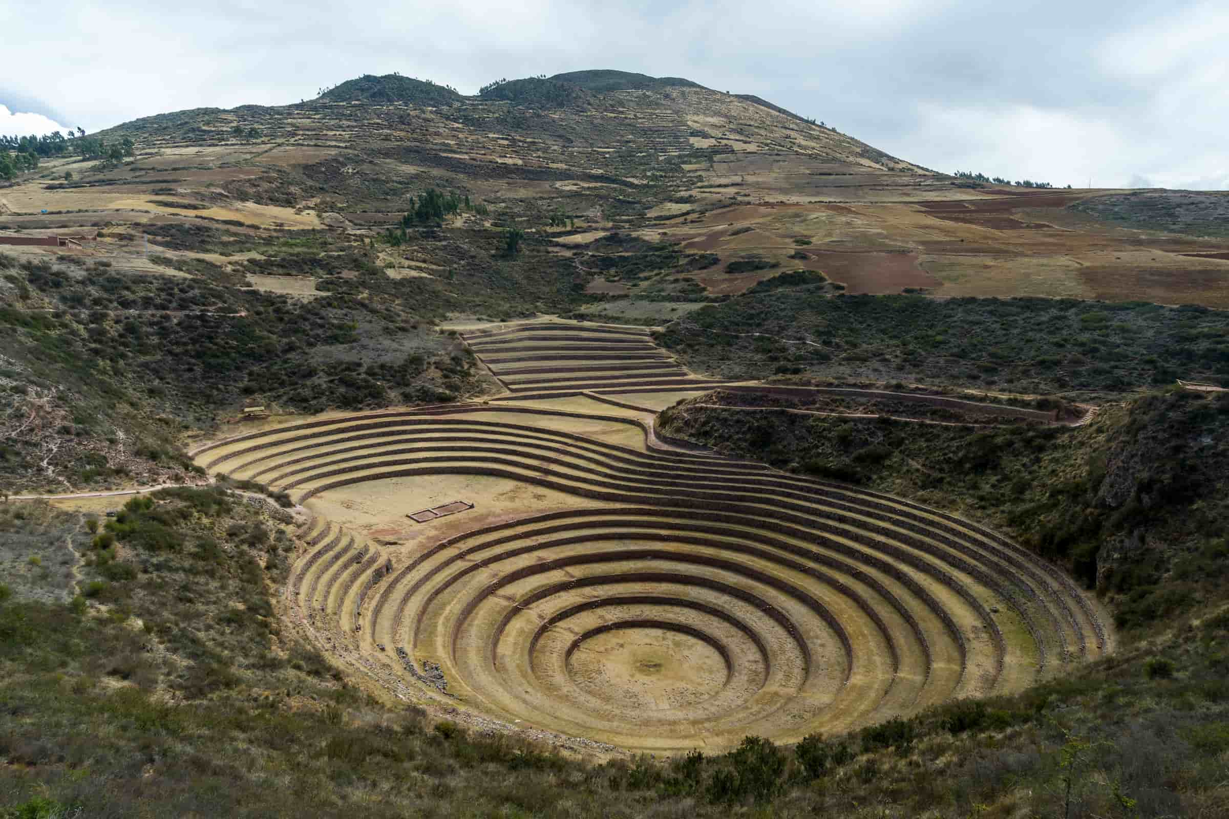
This is a strange place. Area located at 53 km northwest of Cusco, highlights an admirable Inca experimental farm, where a natural depression has been transformed in enormous terraces superimposed in concentric form with a shape of a great coliseum, achieving up to 150 meters in difference of height levels. This technology allowed the old Inca farmers to study the effect of altitude on different plants and create diverse weathers, to experience and to obtain varieties of plants that improved their crops. It was a great laboratory.
Each terrace possesses contention walls and they are connected by a complex system of artificial channels of irrigation that are a sample of the high hydraulic technology that the Inca also reached.
Ollantaytambo
This archaeological complex was a gigantic agricultural, administrative, social, religious and military center in the era of the Tahuantinsuyo. The Spaniards called it the Fortress of Ollantaytambo. It is located 97km from Cusco down a modem highway.
Once can see the architectural style of its streets and squares which are distinctly pre-Hispanic, with enormous polyhedrons forming the walls and trapezoidal doors of temples and palaces. The urban distribution was set along rectilinear and narrow streets which have been inhabited constantly by natives since the Incas’ time.
In the upper and western part of the city rises a mountain which houses innumerable pre-Hispanic constructions such as magnificent crafted temples and terraces. A striking construction is the partially destroyed main temple, where once can see the front stone carving made up of six perfectly built red monoliths. It also has stepped molds, a characteristic made by the Earth. This made academics to consider Ollantaytambo a living museum.
Pisaq
This picturesque town with a blend of mestizo and colonial architecture belong to the province of Calca at the entrance to the Sacred Valley of the Incas, 32Km down a modern highway from the city of Cusco .
Founded during the reign of Viceroy Francisco de Toledo, the town has both Western and native features that make it an original and typical town of the región.
Pisaq Archaeological Complex
In the upper part there are the remains of this re-Columbian settlement located a few kilometers from the mestizo town. It takes up an entire mountain made up of different neighborhood or squares, the main one being Intiwatana, which is admired for the architectural skill with which its constructions were built. At the same time, the pre-Hispani cemetery is also of great interest as it is the largest found in this part of the continent. There are thousands of tombs, some of them looted. The complex is also famous for the colossal terraces that circle the mountains and the fabulous watchtowers which were used as observation points as well as for control and military defense.
Pisaq Arts and Chafts Market
Here merchants offer for sale all sorts of handicrafts, the most important of which are the textiles and ceramic goods such as ceremonial goblets called “Q’eros”, plates, ashtrays, necklace and replicas of pre-Hispanic pottery. There are also ponchos, sweaters and bag The handicrafts fairs are held every Thursday and Sunday in the main square o Pisaq, as well as the Indian market, which is visited by inhabitants from the various native communities to stock up on supplies or sell their products. 0 Sundays, there is also the traditional Mass held in Quechua, which is attended by the Varayoc or village leaders from the surrounding communities.
Urubamba
Located 78km from Cusco via Pisaq and 57km via Chinchero, it is located in the heart of the Sacred Valley and is known as the “Pearl of the Vilcanota” with beautiful countrysides and a healthy climate, located at the foot of the majestic snow-capped peak Chicón.
Urubamba, the archaeological capital of Peru, has many possibilities for tourist activities, especially adventure tourism because of its natural beauty. In the rain season there is an abundance of seasonal fruit. The area was also a pre-Hispanic agricultural center.
Yucay
A historic area, Yucay is a pretty valley inhabited by the Runas of the Tahuantinsuyo who built impressive works of agricultural engineering. This area is important for the palace of the Inca Sairy Tupac 11, a construction made of stone and adobe mud brick with haute- and bas-relief decorations. It was a center of agricultural production for the Incas because of its mild climate, fertile land, abundant water and vegetation, especially fruit trees.
TOURIST SITES AROUND CUSCO
Laqo Lanlakuyoq and Cusilluchayoq
Pre-Hispanic adoration places, located at 5 km. east of Cusco. Representations of felines, monkeys and snakes had been carved in the rocks. It is a particularly interesting place for the followers of occult and spiritual movements.
Qenqo
Sanctuary dedicated to the adoration of animals, ruins formed by a rocky place with stairs in zigzag, it has a main building like a circular amphitheatre where 19 window sills are located as a way of seats.
It is presumed that this place was an adoration place, supporting this presumption the presence of an enormous stone block of 5.9 m. height that has the appearance of a puma. There is labyrinth entrance toward underground galleries, passages, channels, and stairs with signs of a remote culture; these reveal a series of drawings and engravings outstanding the figures of pumas.
It is located at 4 km. of the Main Square, following the way to Sacsayhuamán.
Sacsayhuaman
Sacsayhuaman (Quechua voice Satiate hawk) Inca architectural masterpiece. Impressive megalithic ruins located in the peak of a hill that dominates the north of the city. The historians of the Spanish conquest attributed it military purposes that then became religious, and finally a place of work.
Sacsayhuaman CuscoIts walls are formed by enormous stone blocks that reach up to 9 m. height, 5 m. width and 4 m. thickness. Its biggest is calculated to have a weight of 125 tons; the visitor will wonder how they have been taken there. The union of the enormous rocks was assembled in a perfect way without use of cement. Its main wall is constituted by three successive walls in zigzag, the second and the third superimposed to the first one.
Its platforms have an average of 360 m. length and communicate by stairs, and access doors. The throne of the Inca is surrounded by rocks in front of the ramparts that dominate the esplanade and the “rodadero” (circular place), located in the same plateau.
Sacsayhuamán was scenario of important historical facts, especially during the Spanish conquest. Every year the evocation to the Inti Raymi is celebrated there.
It is located at 3 km. of the Main Square and you can arrive there walking.
Puca Pucara
Puca Pucara is a military construction located near Cusco, in Peru. This fortress is composed of large walls, terraces and staircases and was part of the defensive complex of Cusco in particular and the Inca Empire in general.
In the scope of the archaeological constructions near the capital of the extinct empire, this locality is visited. Puca Pucara receives its name in Quechua of “Red Fortress”, due to the red color that the rocks acquire during the twilight. Puca Pucara is another example of military architecture that also functioned as an administrative center, has terraces, superimposed terraces, stairs and passageways.
Tambomachay
Located 7 km from the city, It was an Inca sanctuary dedicated to the cult of the water, and it was a reserved place for the Inca. It is known as the “Baños del Inca” (Inca’s spa). Construction of fine lithic finishes and high domain of the hydraulic engineering.
It is a group of walls, united by stairs, with springs that fall to a puddle through channels. The fall of water that gets the attention in these ruins part from the terrace of the second wall and the drainage spill on the first where a small puddle is found.
The window sills, hole or niches of 2 m. height, was the place from where according to the historians, the Inca and the important people of his court subdue cult to the god Inti (sun) with rites of water.
COLONIAL AND IMPERIAL CUSCO
Calle Hatun Rumiyoc
This is perhaps the best known street in the city. In one of its walls of carved stone (the Archbishop’s Palace) you can find the famous stone with the 12 corners, identical to the one which forms a part of the old palace of Inca Roca. This street, rich in magnetism, offers an excellent access to the picturesque craft neighbourhood of San Blas.
Church and Convent of the Merced
Founded in 1536, the outstanding feature of the church and the convent is its tower in the Baroque style. In its interior you can find Baroque Renaissance cloisters. The choir is decorated with chairs in the Baroque Plateresque style and numerous figures and paintings of colonial art. There is a monstrance of gold and beautiful stones that is 1.3 m. high and 22 kg. in weight, with a big pearl in the form of a siren, and it is considered the second biggest in the world
Main Square
In the time of the Incas the main square was known as the ‘Square of the warrior’. It has been the scene of several important events in the history of Cusco. Every year the beginning of the spectacular ‘Inti Raymi’ or ‘Fiesta del Sol’ is began here. It was also in the Main Square that Francisco Pizarro proclaimed the conquest of Cusco and it was also the scene for the death of Tupar Amaru I (1571), the commander of the unsuccessful Inca resistance. The arrival of the Spanish saw the Plaza surrounded by beautiful arcades of stone in traditional colonial style, these can still be seen and admired today. In the Plaza you also find the Cathedral and the church of the Society of Jesus.
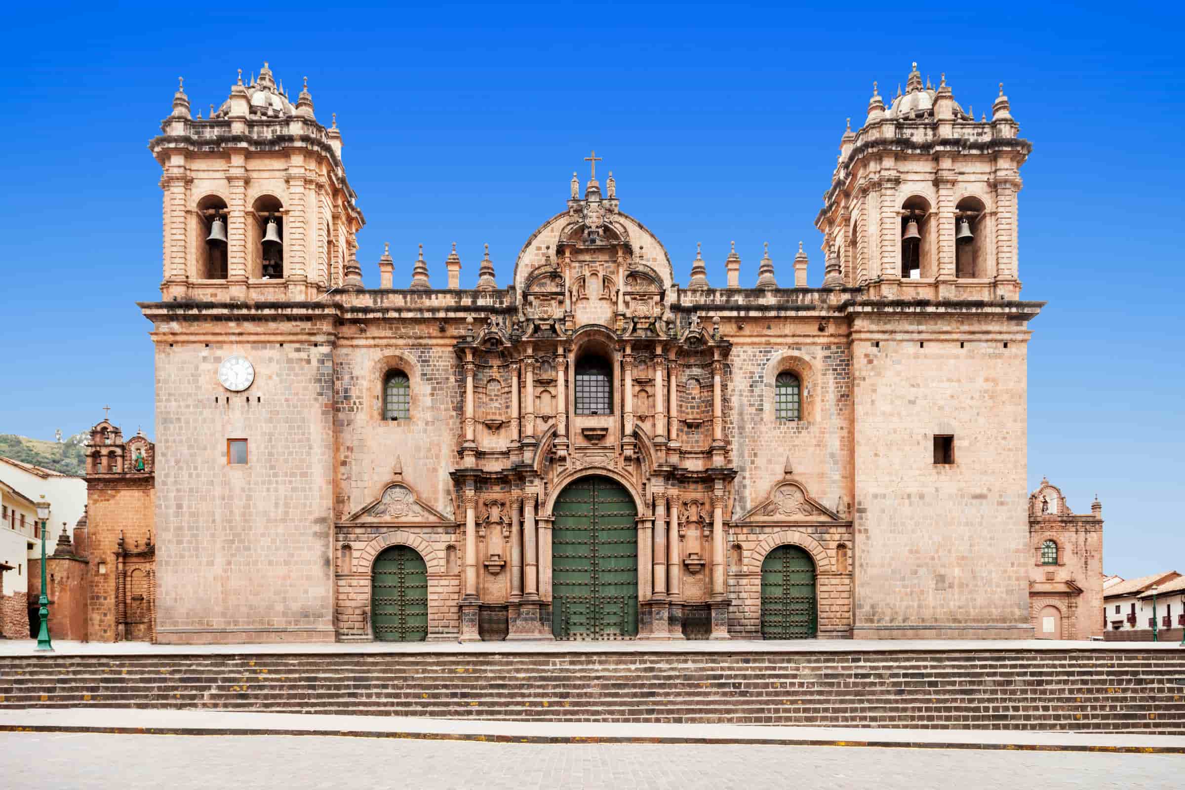
The Cathedral of Cusco
The first cathedral in Cusco was built in 1539 in the “Suntur Wasi”, and was known at the time as the church of victory. Later between the years 1560 and 1664 a new cathedral was constructed on the site of “Kiswar Kancha”, the palace of Inca Wiraqocha. It was designed in the shape of a Latin cross. The facade is in the Renaissance style contrasting with the Baroque and Plateresque. The Cathedral is also famous for its splendid interior. .
It has excellent examples of colonial goldsmith’s work and woodcarving and a valuable collection of canvases in the style of the so called Cusqueña School. On either side of the Cathedral, there are two auxiliary chapels, one for victory and the other for Jesus, Mary and Joseph.
The Church The Society of Jesus
Construction started on this church of the Jesuit order in 1576 at Amarukancha or the Palace of the Inca Huayna Qhapaq. It is considered the best example of colonial Baroque architecture in America. The facade, all of carved stones, is spectacular. In the interior there is a beautiful gold altar, which is built over an underground chapel. The church also possesses a collection of sculptures and paintings, such as the wedding of Saint Ignatius Loyola’s cousin and a Ñusta of Inca stock.
Temple of San Blas
The Temple of San Blas was built in the old neighbourhood of “T’oqokachi” in 16th century. In the church you can see extraordinary examples of fine woodcarving in the Spanish churrigueresque style. The pulpit is carved from cedar wood and the main altar is Baroque style .
San Blas also known as the neighbourhood of the artisans is one of the most picturesque places in the city. Its narrow back streets zigzag between grand old houses built of Inca stones and gentle little squares.
The neighbourhood also houses shops and stores of the most renowned artisans of Cusco, such as Hilario Mendívil and Edilberto Mérida, Santiago Rojas and Maximiliana Palomino.
SOUTH VALLEY
Andahuaylillas
It is located at 3198m.a.s.l. (3100 meters) (10170 feet), 35 km (about 25 miles, 1 hour ) to the south (east) of Cusco by the paved road leading to Puno. Its lands are very fertile and there are two important tourist attractions; it has a church with humble external aspect that keeps one of the most valuable jewels of the colonial art in Peru, denominated the Capilla Sixtina of Peru.” The interior of the Church of San Pedro of Andahuaylillas is an explosion of Baroque art with great quantity of decorations. It was built in 1631, and according to the Spanish tradition, about an Inca temple, it has numerous and beautiful paintings of the Escuela Cusqueña; its altars and wood carvings are beautiful pieces elaborated in leaf of gold, its colored roof is a perfect beauty.
Andahuaylillas is huge square is decorated with “pisonay” (trees of Coral) and the trees of palm. Its greatest treasure is the colonial church of Andahuaylillas.. This church was possibly built over some important Inca temples, maybe “Waka” (the urn). They used carved and sites, from the religious Inca architecture, to build the base of the churches.
Lucre
Small town located at 35 km. (22 miles) southeast of Cusco, beautiful Andean landscapes, and a beautiful lagoon, where families living in Cusco go on Sunday for walks, vacation and recess center.
Very near the city, we find the Lucre lagoon or Huacarpay at about 3200 meters high (10500 feet). This was a shelter of wild fauna species such as wild ducks, geese and flamingos due to the suitable atmosphere produced thanks to totora canes and terraces to cultivate in the rocky faces of the mountains. They also fished trout and atherine.
Pikillacta
Located at 38 km. (23.6 miles) southeast of Cusco, remains of a city that occupied an area of 50 hectares, big buildings, some of two floors, embankments, big walls that reach up to 7 m height, aqueducts. Also highlights the great quantity of colcas (deposits of grains), and the style of their construction, with small stones, put together with mud.
This location is a place where you can also magnify the reach achieved by the Inca in the architecture and urban organization. The historians attribute to this place a character of military defense and center of supplies, for the big deposits of agricultural products, tools, dresses and war weapons that have been found
Pikillacta and the Lucre Lagoon
Pikillacta or City of fleas is a national archaeological park with landscapes of great interest. It is situated in the province of Quispicanchis and covers an area of 8453 acres. It was one of the most spectacular regional centers of the Wari culture.
Pikillacta is a compound word in Quechua that means lousy town (piki: fleas, llaqta: town). Despite of the fact that the original name is not known, this place was called “Pikillaqta” since the last years of the colonial period or at the beginning of the republic.
It is situated at 32 km (20 miles) to the east and at 22 km to the south of the city of Cusco following the asphalted road to Puno. Currently, they use the paved road to Puno and Arequipa. It is at 3150 m.a.s.l.
The constructions of Pikillacta are composed by more than 700 structures: 200 Kanchas (departments), 504 qolqas (storages) and different buildings that should have sheltered a population of about ten thousand people.
The city was displayed in a harmonious and symmetric way, in blocks with straight streets that embraced many sectors such as the administrative, ceremonial, urban, defensive and a road system. Its buildings had 2 or 3 floors of 12 meters high each one.
Raqchi
Raqchi is part of the district of San Pedro de Cacha, province of Canchis. Is located on one side of the Vilcanota river at 3500 meters (11500 feet). It seems that its Prehispanic name was “Cacha” instead of “Raqchi” .
There are evidences proving that Raqchi was a complex town of multiple constructions, even the terraces to cultivate had different purposes. “Kanchas” (apartments), “wayranas” (building of only three walls), “qolqas” (storages), different urns, the religious fountains, etc. It was possibly an important “tambo” along the route to go to Collayuso.
The most important building inside the complex is the “Wiracocha temple” that according to the old chroniclers was built by the Inca Wiracocha in honour to the Superior God invisible for the Andean people: “Apu Kon Titi Wiracocha”.
Rumicolca
Inca archaeological area, located at 39 km. (24.2 miles) southeast of Cusco and at 1 km. (0.62 miles) of Piquillacta. It constituted the main and obligatory entrance to Cusco in the route to the Collasuyo (county of the south, in the Tahuantisuyo), with functions of customs. A great and imposing cover built in carved stone, surrounded with high walls in which inferior vertex a water channel runs, also a great aqueduct that was used to take water to the population of Piquillacta.
Tipón
Inca archaeological area, located at 23 km. (14 miles) southeast of Cusco. Agricultural area, megalithic buildings and a citadel. A great “andenería” (terraces) group, with terraces of great size that diminish of area when ascending to the mountain. A great wall goes over all the contours of this area; at the center a group of buildings built with immense rocks, and remains of an old citadel. In this area a great Inca population existed.
The original name in Quechua is unknown. You can admire several royal rooms that according Victor Angles were built by the Inca Wiracocha as a house and shelter for his father Yawar Wakaq who returned after the war against the Chankas.
This group of village is at 3500 meters (11480 feet). Besides there is a big area to cultivate with walls built with stones perfectly carved. Even more impressive is the system of the irrigation that is still used in agriculture.
The advantage is the water captured in the spring season. The river is channelled by some carved stones that have been accurately calculated, they sometimes form falls almost vertical composing an excellent hydraulic engineering work. Some of the fountains must have ceremonial purposes. Due to its location and the existence of a round wall, Tipon must have been a very exclusive place interdependent to other sectors such as “Intiwatana” to the west, “Pukutuyoq”, “Pukara”, “Hatun Wayk’o”, etc.